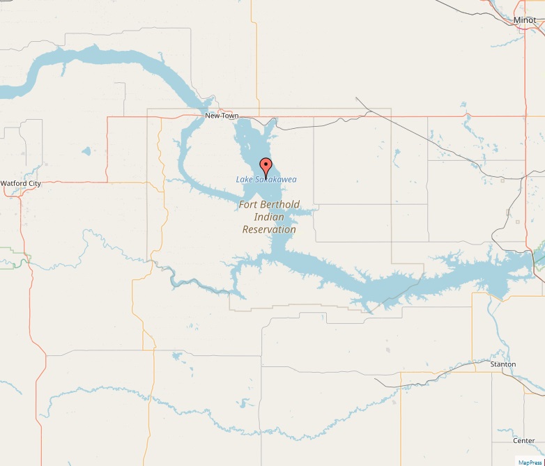
Lake Sakakawea

Lake Sakakawea

Lakes
Lake Sakakawea, named after the Shoshone-Hidatsa woman who accompanied the Lewis and Clark Expedition, is a vast reservoir in North Dakota, United States. Formed by the impoundment of the Missouri River by Garrison Dam, it stands as one of the largest man-made lakes in the United States, both in area and volume. Geography and Hydrology Located at coordinates 47.50°N 101.41°W, Lake Sakakawea stretches for 178 miles and encompasses a surface area of 307,000 acres. The lake's maximum depth reaches 180 feet near the dam. It spans across several North Dakota counties, including Dunn, McKenzie, McLean, Mercer, Mountrail, and Williams. The lake's width varies, averaging 2–3 miles, with a maximum width of 14 miles at Van Hook Arm. History Lake Sakakawea's creation is linked to the construction of Garrison Dam, a…
Read More
Lake Pontchartrain Map

Lake Pontchartrain Map

Lakes
Lake Pontchartrain, an estuary located in southeastern Louisiana, is a prominent geographical feature in the United States. With a surface area of 630 square miles, it is the largest lake in Louisiana and holds a significant place in the region’s ecology, culture, and history. Geography and Hydrology Lake Pontchartrain is an estuary connected to the Gulf of Mexico, mainly fed by the Tangipahoa, Tchefuncte, Tickfaw, Amite, and Bogue Falaya rivers, along with Bayou Lacombe and Bayou Chinchuba. The lake's oval shape measures approximately 40 miles west to east and 24 miles south to north. It is located in parts of six Louisiana parishes: St. Tammany, Orleans, Jefferson, St. John the Baptist, St. Charles, and Tangipahoa. Toponymy The lake is named after Louis Phélypeaux, comte de Pontchartrain, a French statesman during…
Read More
Lake Okeechobee

Lake Okeechobee

Lakes
Lake Okeechobee, prominently located in Florida, USA, is the largest freshwater lake in the state and the tenth largest natural freshwater lake in the United States. Known for its unique ecological characteristics, Lake Okeechobee plays a crucial role in Florida's environment and hydrology. Geography and Hydrology Situated at coordinates 26°56′N 80°48′W, Lake Okeechobee spans an impressive 734 square miles, with a maximum length of 36 miles and a width of 29 miles. Despite its vast surface area, the lake is relatively shallow, with an average depth of around 9 feet. The primary inflows of the lake are the Kissimmee River, Fisheating Creek, and Taylor Creek, while its primary outflows lead to the Everglades, Caloosahatchee River, and St. Lucie River. Geological Background The lake is part of a shallow geological trough…
Read More
Lake Oahe

Lake Oahe

Lakes
Lake Oahe, a vast reservoir located in the United States, stretches from central South Dakota into North Dakota. Created by the Oahe Dam on the Missouri River, it is a prominent feature in the region, known for its recreational opportunities and historical significance. Geography The lake, positioned at 44°27′04″N 100°24′08″W, is one of the largest reservoirs in the United States. It covers an area of 370,000 acres and has a remarkable length of approximately 231 miles, making it the fourth-largest reservoir in the country by volume. The maximum depth of Lake Oahe is 205 feet, and it boasts an extensive shoreline of about 2,250 miles. Hydrology As a reservoir, Lake Oahe receives water primarily from the Missouri River, supplemented by other tributaries like the Cheyenne River, Moreau River, and Grand…
Read More
Great Salt Lake

Great Salt Lake

Lakes
The Great Salt Lake, situated in the northern part of Utah, United States, is renowned as the largest saltwater lake in the Western Hemisphere and the eighth-largest terminal lake globally. This unique body of water is a remnant of Lake Bonneville, a prehistoric lake that once covered a vast area of western Utah. Geography Occupying coordinates 41°10′N 112°32′W, the Great Salt Lake has a maximum length of 75 miles and a width of 28 miles. The lake's surface area, as of 2021, stands at 950 square miles. Notably shallow, its average depth is 16 feet, with the maximum depth averaging around 33 feet. The Great Salt Lake's primary tributaries include the Bear, Jordan, and Weber Rivers. Hydrology The lake's catchment area spans over 21,500 square miles. Due to its endorheic…
Read More
Iliamna Lake

Iliamna Lake

Lakes
Lake Iliamna, located in southwest Alaska, is the largest lake in the state and holds a significant position in both geography and local lore. It is situated at the north end of the Alaska Peninsula, between Kvichak Bay and Cook Inlet, and is known for its breathtaking natural beauty and rich biodiversity. Geography With coordinates 59°32′12″N 155°01′28″W, Lake Iliamna measures 77 miles in length and 22 miles in width, covering a surface area of 1,012.5 square miles. It reaches a maximum depth of 988 feet, making it one of the deepest lakes in the United States. The lake's primary inflows include the Newhalen River, Iliamna River, Pile River, and Copper River, with its primary outflow through the Kvichak River into Bristol Bay. History and Name The lake's name has evolved…
Read More
Lake of the Woods

Lake of the Woods

Lakes
Lake of the Woods, straddling the borders of Canada and the United States, is a remarkable freshwater body known for its vast expanse and unique geographical features. Situated between Ontario and Manitoba in Canada, and Minnesota in the United States, it presents a fascinating blend of natural beauty and recreational opportunities. Geography The lake, located at coordinates 49°14′59″N 94°45′03″W, stretches over 70 miles in both length and width, encompassing an area of 1,679.5 square miles. It boasts an impressive shoreline, including islands, extending over 65,000 miles. The primary inflows to Lake of the Woods are the Rainy River, Shoal Lake, and Kakagi Lake, while its primary outflow is the Winnipeg River, leading into Lake Winnipeg and eventually flowing into Hudson Bay. Environmental Significance Lake of the Woods is the sixth…
Read More
Lake Ontario

Lake Ontario

Lakes
Lake Ontario, a significant member of the North American Great Lakes, holds a distinct place due to its location and ecological significance. As the easternmost Great Lake, it is vital for both the United States and Canada, being bordered by Ontario to the north and New York to the south. Geography Positioned at 43.7°N 77.9°W, Lake Ontario has a maximum length of 193 miles and a width of 53 miles, with a surface area of 7,323 square miles. It is the smallest in surface area among the Great Lakes but surpasses Lake Erie in volume. The lake's average depth is 283 feet, with a maximum depth of 802 feet, making it notably deep. Hydrology The lake's primary inlet is the Niagara River, which flows from Lake Erie. Lake Ontario plays…
Read More
Lake Erie

Lake Erie

Lakes
Lake Erie, one of the prominent Great Lakes of North America, holds a unique position due to its geographical and ecological characteristics. As the fourth-largest by surface area among the Great Lakes and the eleventh globally, Lake Erie has a distinct identity, being the southernmost, shallowest, and smallest by volume of the Great Lakes. Geography Positioned at coordinates 42.2°N 81.2°W, Lake Erie has a surface area of 9,910 square miles, making it a significant geographical feature on the North American landscape. The lake stretches 241 miles in length and reaches up to 57 miles in width. Despite being the shallowest of the Great Lakes, with an average depth of 62 feet and a maximum depth of 210 feet, Lake Erie plays a crucial role in the region's hydrology and ecology.…
Read More
Lake Michigan

Lake Michigan

Lakes
Lake Michigan, a natural marvel within the Great Lakes of North America, stands out due to its vast size and unique characteristics. This lake, entirely located within the United States, is renowned for its expansive shoreline and significant cultural and ecological importance. Geography and Features With coordinates at 44°N 87°W, Lake Michigan is remarkable for being the second-largest of the Great Lakes by volume and the third-largest by surface area. It boasts a maximum depth of 923 feet, an average depth of 279 feet, and spans an impressive surface area of 22,404 square miles. The lake is connected to Lake Huron through the Straits of Mackinac, forming a single hydrological entity. Hydrology and Climate Lake Michigan's unique hydrology features the Milwaukee Reef, dividing it into northern and southern basins. These…
Read More