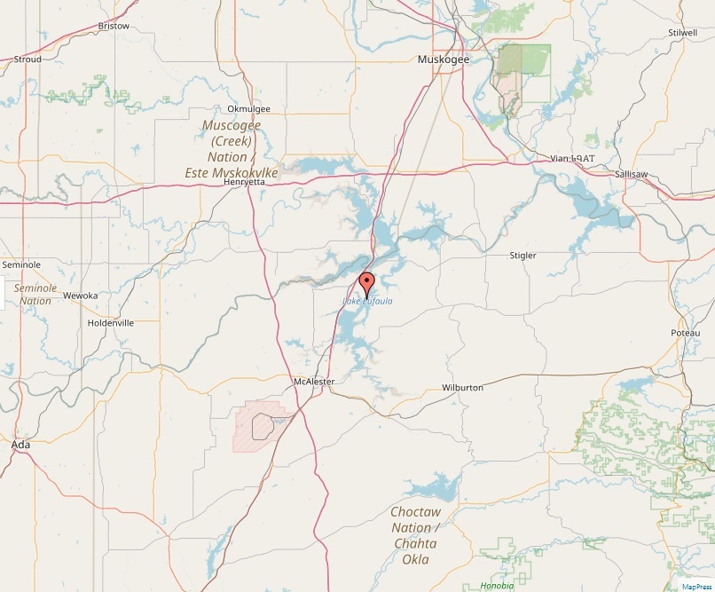
Lake Eufaula

Lake Eufaula

Lakes
Lake Eufaula, nestled in Oklahoma, is a reservoir formed on the Canadian River near the town of Eufaula. It spans Haskell, McIntosh, Pittsburg, and Okmulgee counties, covering a massive area of 102,000 acres. As the largest-capacity lake in Oklahoma, Lake Eufaula is a prominent feature in the region, both in terms of its size and its utility. Geographical Significance The lake, with its vast expanse and 600 miles of shoreline, drains a substantial area of 47,522 square miles. It holds a significant volume of water, estimated at 2,099,000 acre-feet. The lake's average depth is around 23 feet, with some areas reaching depths of up to 87 feet. Its primary inflows are the North and South Canadian Rivers, and it serves as a crucial component of the region's hydrographic network. Historical…
Read More
Lake Francis Case

Lake Francis Case

Lakes
Nestled in the heart of South Dakota, Lake Francis Case stands as a majestic reservoir, stretching over 107 miles along the Missouri River. Named after U.S. Senator Francis Higbee Case, this vast body of water, impounded by the Fort Randall Dam, serves as a recreational haven and an ecological sanctuary. Historical Context The story of Lake Francis Case begins with the construction of the Fort Randall Dam, initiated under the Flood Control Act of 1944. The dam's construction, starting in 1946 and culminating in its inauguration by President Dwight D. Eisenhower in 1954, created the reservoir that would become Lake Francis Case. This development, however, came at a cost. The formation of the lake led to the flooding of White Swan, a Native American settlement, displacing its residents to places…
Read More
Lake Hartwell

Lake Hartwell

Lakes
Lake Hartwell, a sprawling reservoir straddling the borders of Georgia and South Carolina, stands as a testament to human engineering and natural beauty. Created by the construction of the Hartwell Dam on the Savannah River, this lake has become a central hub for recreational activities and ecological study. Background Authorized by the Flood Control Act of 1950, the Hartwell Dam and Reservoir were envisioned as a multipurpose project to facilitate flood control, power generation, and navigation. The project began in 1955 and reached completion in 1963, reshaping the landscape and local communities. It was named in honor of Nancy Hart, a heroine of the American Revolutionary War known for her unwavering commitment to freedom. Geographical and Hydrological Features Lake Hartwell, with a surface area of 56,000 acres and a maximum…
Read More
American Falls Dam

American Falls Dam

Lakes
Nestled in Power County, Idaho, American Falls Dam stands as a significant structure on the Snake River. It serves multiple purposes including flood control, irrigation, and recreation. This concrete gravity-type dam, with its expansive reservoir, has played a crucial role in the region's development since the early 20th century. Construction and History The original American Falls Dam was constructed in the 1920s by the United States Bureau of Reclamation. The construction necessitated the relocation of a significant portion of the town of American Falls, marking a monumental change for local residents. In 1978, a new dam was completed, and the original structure was demolished. This modern dam was an essential upgrade to meet the growing needs of the region. Geology and Geography The area where the dam stands has a…
Read More
Lake Sharpe

Lake Sharpe

Lakes
Nestled in central South Dakota, Lake Sharpe is an expansive reservoir, a testament to human engineering and a natural paradise. Created by the Big Bend Dam on the Missouri River, this lake is an integral part of the region's ecosystem and a hub for recreational activities. Geographical Layout Spanning an impressive 56,884 acres and reaching depths of 78 feet, Lake Sharpe stretches approximately 80 miles in length with a 200-mile shoreline. The lake’s vastness ranks it as the 54th largest reservoir in the United States. It sprawls across multiple counties, including Buffalo, Lyman, Hyde, Hughes, and Stanley, and runs from Ft. Thompson to the Oahe Dam near Pierre. Historical Background Construction of the Big Bend Dam began in 1959, leading to the formation of Lake Sharpe. The lake was named…
Read More
Lake Barkley

Lake Barkley

Lakes
Lake Barkley, a vast reservoir in Kentucky and Tennessee, stands as a testament to modern engineering and a hub for outdoor recreation. This lake, named in honor of former Vice President Alben Barkley, a Kentucky native, is a key feature in the region's landscape and recreational life. Geographical Overview Spanning across Livingston, Lyon, and Trigg Counties in Kentucky, and extending into Stewart and Houston Counties in Tennessee, Lake Barkley covers a striking 58,000 acres. Created in 1966 by the U.S. Army Corps of Engineers with the construction of Barkley Dam, it primarily serves as a flood control and recreational area. The lake is fed and drained by the Cumberland River, situated near Grand Rivers, Kentucky. Its proximity, just 38 miles upstream from the confluence of the Cumberland and Ohio Rivers,…
Read More
Lake Winnibigoshish

Lake Winnibigoshish

Lakes
Nestled in north-central Minnesota, Lake Winnibigoshish, fondly known as "Lake Winnie," is a remarkable natural reservoir situated within the Chippewa National Forest. It is a destination celebrated for its serene beauty, rich history, and diverse recreational activities. Etymology The lake's name, derived from the Ojibwe language, means "filthy water," signifying "brackish water." This unique name, with its roots in the indigenous language, reflects the cultural heritage of the region and echoes the names of other significant lakes in the Algonquian linguistic sphere. Geographical Significance Spanning an impressive 56,471 acres, Lake Winnibigoshish stands as Minnesota's fourth-largest lake. It plays a pivotal role in the Mississippi River system, being one of the river's broadest points, stretching over 11 miles wide. The Mississippi River, originating from Lake Itasca, courses through Lake Winnibigoshish, adding…
Read More
Lake Moultrie

Lake Moultrie

Lakes
Lake Moultrie, a significant man-made lake in South Carolina, stands as a testament to human ingenuity and nature's splendor. Created in the 1940s for hydroelectric power, it has since transformed into a hub of recreational activities, attracting visitors from all corners. Location and Geographical Features Situated in Berkeley County, Lake Moultrie's expanse is fed by the Santee River, flowing through Lake Marion and a diversion canal. It is neighbored by the towns of Moncks Corner, Bonneau Beach, Cross, and St. Stephen, making it easily accessible for both locals and tourists. Historical Background The lake owes its existence to the South Carolina Public Service Authority's ambitious project in the 1940s. Named after Governor William Moultrie, the lake was part of a larger scheme involving the construction of Pinopolis Dam for flood…
Read More
Tustumena Lake

Tustumena Lake

Lakes
Tustumena Lake, known in the Dena'ina language as Dusdu Bena, is a remarkable natural wonder situated on the western side of Alaska's Kenai Peninsula. Nestled within the expansive Kenai National Wildlife Refuge and near the town of Kasilof, this remote lake stands out as a symbol of Alaska's wild and untamed beauty. Overview Tustumena Lake is Alaska's eighth-largest lake, covering an impressive 73,437 acres (297.19 km²). It is renowned for its extraordinary depth, reaching a maximum of 950 feet, making it deeper than the nearby Cook Inlet. The lake stretches for 25 miles in length and expands up to 6 miles in width. Its primary inflows include Glacier Creek and other small streams, and it serves as the headwaters of the Kasilof River. Access to Tustumena Lake is exclusively via…
Read More
Upper Klamath Lake

Upper Klamath Lake

Lakes
Nestled in the heart of south-central Oregon, Upper Klamath Lake is a marvel of natural beauty and ecological significance. Known to the Klamath as ?ews, meaning "lake," this expansive body of water is the largest in Oregon by surface area and plays a crucial role in the region's ecology and human activity. Geography and Hydrology Spanning approximately 25 miles in length and 8 miles in width, Upper Klamath Lake is situated east of the Cascade Range, near Klamath Falls. It lies at an elevation of 4,140 feet and is fed by a 3,768 square mile watershed, including the Williamson and Wood Rivers. The lake's primary outflow is the Klamath River, flowing south from the lake. The lake's surface area covers 61,543 acres, with an average depth of 14 feet, although…
Read More